
-
*Astrella

 .
.User deleted
Royston Cave – A Knights Templar Mystery of History
Since its discovery in 1742, many theories have been put forward regarding the excavation, use and meaning of Royston Cave. But are we any closer to uncovering the truth, or has its secrets already been given to us in the form of the movie, The Da Vinci Code?
Royston is situated in northern Hertfordshire and originally sat within five parishes, in two counties; Bassingbourn, Kneesworth and Melbourn in Cambridgeshire, and Therfield and Barkway in Hertfordshire (Brayley 1808).
The town is situated at the crossroads of two well known historical roads, the Icknield Way, an ancient track possibly Iron Age or before (Brighton 2008: 96), and Ermine Street, a Roman road which ran from London to York.
Just west of the town are the ancient and well known Mile Ditches, ancient dykes which ‘came down from a tumulus on the southern side, and run down to Bassingbourn Spring Head, a distance of about two miles on the Northern side’ (Beldham 1849:28). Royston currently sits on the Prime Meridian (Olson 2011: 88) and did ot become a town until relatively late, thus has no mention in the Domesday Book of 1086.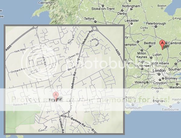
The area is surrounded in history. Nearby at Therfield Heath are ancient tumuli, barrows and a settlement, several Roman posts were located along Ermine Street and numerous Roman coins have been found in and around the Royston area (Beldam 1858),. In addition are Roman dedications to the God Mars, found at nearby Barkway and now housed in the British Museum.
The town is believed to have developed around a cross which was erected there by the Lady Roisia,
Who some think to have been the daughter of Aubrey de Vere, Chief Justice of England under King Henry I and wife of Geoffrey de Mandeville, the first Earl of Essex, while others say, the wife of Richard de Clare, and others the Countess of Norfolk (Carter 1819: 259).
However, recent research has shown that de Vere’s daughter never lived at or near Royston and therefore ‘takes its name from Rohesia, daughter of Eudo Dapifer (Baring-Gould 2004: 226). To further confuse things, Beldam also states that,
Local and vernacular name for the spot, frequently occurring in the earliest Priory deeds, and Latinized into ‘Roæsie,’ which is variously spelt ‘Roys,’ ‘Rous,’ Roheys,’ words which certainly have much of a Scandinavian character….And various Saxon words, almost identical in sound….such as ‘Hreaws’ pronounced ‘Raws’ meaning a funeral, ‘Reowes,’ pronounced ‘Roes’ signifying sorrow or mourning (Beldam 1858: 9).
The latter certainly makes more sense especially when noting the tumulus and ancient remains that have been uncovered in the surrounding area. So the origins of the name may lay in the Dark Ages, and not during medieval times, as is so often believed.
The medieval cross, at the intersection of the two historical routes, may have been erected upon the spot of an older Roman marker,
Between the dome of the Cave and the line of the Ermine Street, being in the parish of Barkway, and in the fee of the Lordship of Newsells (Beldam 1858: 7).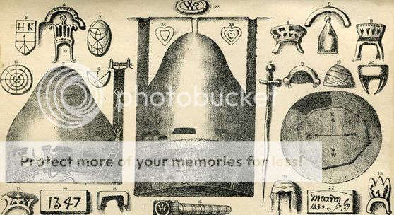
And it was near this cross that Eustace de Mere and his nephew Ralph de Rovecester, holders of the Manor of Newsells, founded a ‘monastery for Austin Cannons , in honour of St. Thomas of Canterbury’ (Brayley 1808: 179). Over time, and with the needs required by those visiting the monastery, a small town developed, and included a hospital dedicated to St. Nicholas and another religious foundation ‘but no particulars concerning it are known’ (Brayley 1808: 181).
The name then changed from Rosie’s Cross, to Rosie’s Town, and over time was shortened to Roiston, and then the modern spelling of Royston.
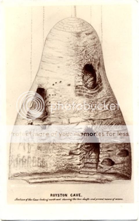
Workmen digging a hole for a post, in August 1742, for a new bench, discovered Royston Cave. They sent a small boy into the opening, which had been sealed closed by a mill-stone, to find out what it contained. A larger hole was cut through the chalk to allow for its clearance, as the locals believed there may be some hidden treasure within.
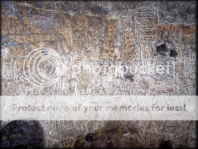
When it was emptied of ‘garden mould’ the walls were found to be covered with engravings of saints…. Little was found in the infill, a human skull and one or two other bones, a piece of brass lacking any description and a few pieces of medieval pottery. Later a seal with a single Fleur de Lys design on it was handed in (Olson 2011: 89-90).
Archaeology was not a known profession back in those days and the infill was just ditched somewhere – to find those bones and DNA test them may lead to some answers as to what the cave was, and even possibly what it was used for.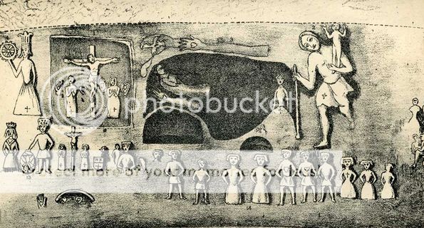
The cave was cleaned and ‘about two hundred loads of earth were drawn out’ (Brayley 1808: 182) before the site was completely cleared. A grave was found located directly beneath the shaft and was enclosed by red brick. It measured seven foot six inches long, three foot wide and two foot deep and had been disturbed. Artefacts in the grave included oak fragments, a possible iron candle holder, various other small pieces of iron, a lump of charcoal, a number of animal bones, pieces of glass, leather and wood, as well as some other objects of ‘doubtful character’ (Beldam 1858: 18-19). These were all taken away and have since been lost in time and space – unfortunately, as the charcoal would have been great for 14C testing (Radiocarbon dating).
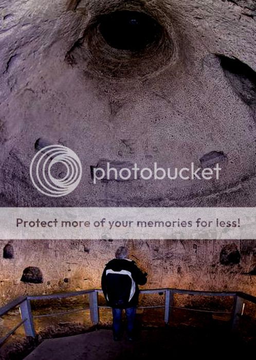
In 1852 the Cave was examined more closely, and is almost the same as can still be seen today,
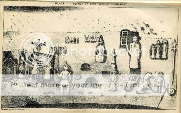
A man-made bottle-shaped underground cavern, some 30 feet (9m) high and 18 feet (5.5m) in diameter, appears to be two-storied, lying above and below a reticulated frieze (Olson 2011: 89).
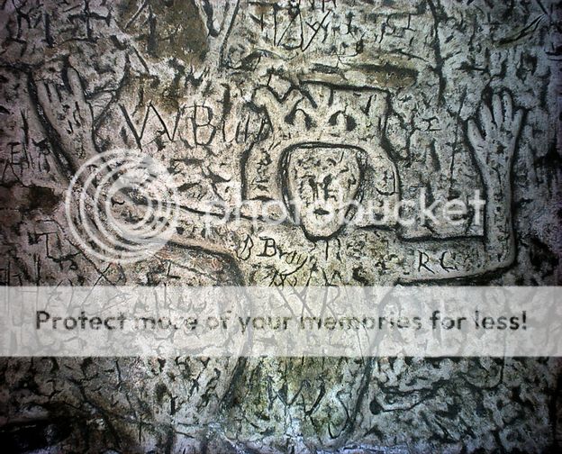
The carvings were first of all thought to depict Christian scenes, as they were interpreted as showing the Holy family, St. Christopher, St. Katherine, St. Lawrence, St. Andrew’s Cross, the Apostle John and Joseph and Mary (Brayley 1808: Beldam 1858; Olson 2011). However, there are also Pagan symbols and images mixed in with them and include a Shiela-na-gig, ‘ a female figure depicted with enlarged sexual organs that she is manipulating to display to full effect’ (Brighton 2008: 98).
This carving appears beside a horse, a sword and a disk, interpreted as Pagan (Lethbridge 1957: 138), but yet contemporary with the other figures. With the Christian and Pagan symbols represented together there is a wide held belief that the carvings were cut by the Knights Templar (Mazel et al. 2007: 5). The dating of the site, according to Beldam (1858) fits to within the time that the Order was alive and active, but the stylistic designs on some of them date after this.
Carved upon the walls of the Cave are the dates 1350 and 1347. Although these may be taken at face value, a closer look at them has made others question whether they are authentic or not. The 1347 date is carved in Arabic numerals. Beldam did not believe this date to be authentic due to firstly, their location being in an inaccessible position, on the ceiling of the dome shape of the roof, and secondly to the shape of the numerals were more akin to those used in the 15th century and not before (Beldam 1858: 51).
Baring-Gould (2004) concludes that ‘Arabic numerals were not in use in England in the fourteenth century’ (Baring-Gould 2004: 225), however, my argument is that the Knights Templar were Crusaders who fought in the Holy Lands where Arabic was used, and hence they could easily have carved the numerals and used them as a clue to the Cave being created by Templars. Many of the Crusaders spoke some Arabic and they could easily have picked up some of the numerals whilst on Crusade.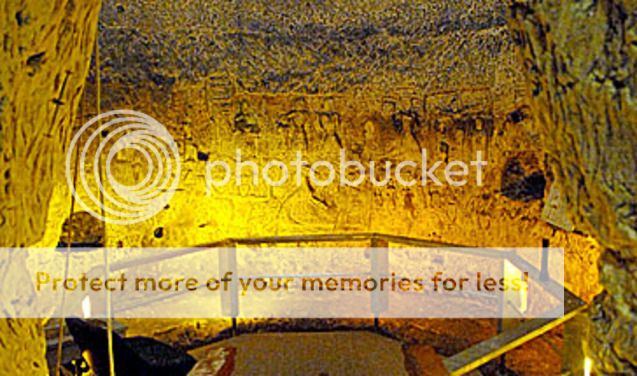
The other date of ’18 February 1350’ with the name ‘Martin’ is a bit more difficult to interpret. According to Beldam they are written ‘by an amateur hand in Old English characters’ (Beldam 1858: 52). He goes on further to say that the dates may have been incorrectly written and should read 1550 and 1547, dating then to the time of the Reformation, the time when the Cave is believed to have been closed up to save it from being destroyed, and the dates mark the time of its closing (Beldam 1858: 53). As with the rest of this Cave, this is a debate that will continue.
The Knights Templar have been credited with carving the Cave as there are many similarities between it and some of their other structures. They built mostly round churches, as in the Temple Church, London, and ‘it’s vertical bell-shape is similar to structures found in Palestine and Czechoslovakia’ (Lord 2004: 81), also, ‘The images as a whole have some similarities with other known Templar carvings at the castle of Chinon and Lincoln’ (Brighton 2008: 98), and The Templars, including Jacques de Molay, the Grand Master, were imprisoned in the Tower de Coudray, Chateaux de Chinon, France on suppression of the Order, and a panel of graffiti including this symbol [Hebraic quaph] is attributed to these prisoners (Olson 2011: 94).
This is a possible link to the two sites and the Knights Templar. There is also the Templar symbol of the two knights on a horse depicted in the Cave, but whether this was carved by a Templar or not will probably never be known. But what is widely known is that the Templars built underground passages and used them.
Hertfordshire was a county used a lot by the Knights Templar.They had their main Preceptory in England at Temple Dinsley, now a girl’s school, as well as being associated with Hertford Castle, and owning the town of Baldock, just outside of Royston, as well as manors at Chelsing, Bengeo and Weston (Lord 2004: 81). Tunnels were discovered under Hertford Castle in 2004 and have been attributed to the Templars, which ‘connect the dungeons at Hertford Castle with the County Hall and other locations’ (Hodapp & Kannon 2007: 335). Rumours have grown rife since the discovery of the tunnels including a labyrinth under the county in order to move the vast amounts of treasure that the Templars are reported to have amassed over time. ‘One version suggests that the Holy Grail is concealed there. Another hints that it is the hiding place of the Ark of the Covenant’ (Fanthorpe & Fanthorpe 2005: 40). But what does all of this have to do with Royston Cave?
Suggestions have been put forward that the Cave was a hiding place during the suppression of the Order in 1309, During a three month period taken up with the exchange of letters, quite a number of Templars quietly disappeared to Scotland. And the road from Dover, London passes through Royston, and via York leads to Scotland (Olson 2011: 95)
Could the Cave, once believed to have been as storage place for market goods from Baldock (Beaman 1992: Lord 2004: Olson 2011) then changed its use to hide Templars on their voyage north to the safety of Scotland? Or was it simply a burial shaft, or an underground chapel used during market days after the Templars had had a falling out with the Priory over their free stallage granted under King John and Henry III at the weekly market granted to the town? (Olson 2011: 92). Whatever its use – it is not the only one in Royston.
There is recorded evidence of other shafts and subterranean chambers existing in and around Royston. But other bone shafts (probably many) exist in the town, several of which have been partially opened, along the sides of Inchinhilde and Ermine Streets. They all exhibit the same peculiarity of rude workmanship, the diameter extremely small, and footholds down the shafts on either side
…. One of these in a garden in the Erming Street, now called Kneesworth Street, I found it to be of a depth of 100 feet, terminating in a fine spring of water; but like the others, it had been filled up, at some remote period…….. In another garden along the Ichenhilde Street, now called Baldock Street, was found a circular cavern beneath a low mound, the floor being grooved in order to carry off water, and evidently designed as a rude habitation or a place of refuge. (Beldam 1849: 27).
Research so far has uncovered no mention of these other sites either in or around Royston, the only other reference I have managed to find states that, Several pits and chambers excavated or sunk in the chalk have been recorded in the Royston district. Whether their original use was as habitations or refugees, or whether they were flint mines in unknown; the majority were probably pre Roman. Beldam (1868) remarks that ‘in the neighbourhood tradition speaks of several caves or caverns having been broken up within the present century” the best known example is the Royston Cave (Fox 1923: 141).
If this is true, then where are these other caves located? How could they have just disappeared without a trace? Royston Cave is noted as being the ‘best known example’, and if this is so then there are other caves waiting to be rediscovered. Even if they have been filled in then archaeology can at least answer some of the questions we have surrounding them, such as how many are there in the area? Is there any datable evidence? To which period in history can we place these caves? And many other questions which can give us a better understanding of the area and in particular to Royston Cave itself.'Royston Cave - Grapevine of the Knights Templar'
Source: http://www.heritagedaily.com/2011/10/royst...tery-of-history .
.
Royston Cave – A Knights Templar Mystery of History12 Dicembre 2013 |