
-
Sylvhia

 .
.User deleted
Kaindy - Sunken Forest in Kazakhstan
The 1911 Kebin earthquake, or 1911 Chon-Kemin earthquake, struck Russian Turkestan on 3 January. Registering at a 7.7 magnitude, it destroyed more than 770 buildings (which was almost all of the city) in Almaty, Kazakhstan, and resulted in 125 miles (201 km) of surface faulting in the valleys of Chon–Kemin, Chilik and Chon-Aksu.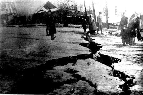
The Tien Shan mountains form part of the broad zone of deformation associated with the continuing collision between the Indian Plate and the Eurasian Plate. In the region around Issyk Kul, the tectonic regime is a combination of thrusting and sinistral strike-slip. The lake is a depression bounded to both north and south by opposite verging thrust faults, while the major Chon-Kemin–Chilik strike-slip fault runs along the linear valleys to the north. Credits to Mikenorton (Own work)
In the Chong-Kemin and Chilik valleys, and on the shoreline of Issyk Kul, a complex zone of surface ruptures was identified by fieldwork immediately following the earthquake. Two main zones of rupture were noted, one complex zone along the Chon-Kemin and Chilik valleys, the other along the Chon-Aksu valley
Many landslides and rock avalanches were triggered by the earthquake and are associated with the mapped zones of surface rupture.The two largest landslides were the Kaindy rock avalanche and the Ananevo rockslide.
The Kaindy landslide, was formed of a mass of limestone.
The Ananevo rockslide was formed of weathered granitic material, with a 250 m high backscarp that is still visible.Lake Kaindy
Lake Kaindy, meaning the "falling rocks/landslide lake"-- is a 400-meter-long (1,300 ft) lake situated near the village of Saty, 129 kilometers (80 mi) east-southeast of the city of Almaty, in the Kungey Alatau Mountains (a range in the North Tien-Shan) in the central Asian country of Kazakhstan
The 1911 earthquake triggered a large landslide blocking the gorge and forming a natural dam. Subsequently, rainwater filled the valley and created the lake.
The water level increased and sumerged the forest and create the particular landscape that today we can see.
Many bare trunks, similar to sunken ships' masts, emerge from water while below the water surface, they still have branches , even after more than a hundred years.
Kaindy - Sunken Forest in Kazakhstan
by Astana Guide
http://en.wikipedia.org/wiki/Lake_Kaindy
www.amusingplanet.com/2012/07/sunke...ake-kaindy.html
http://en.wikipedia.org/wiki/1911_Kebin_earthquake .
.
Kaindy - Sunken Forest in Kazakhstan01 Ottobre 2014 |
